Friday, January 31, 2014

Weather Forecast 1/31/14

During today's walk to class I recorded temperatures back in the negatives at -6 degrees with the wind chill making it feel like -14.  The walk was especially arduous today due to the 4-5 inches we received yesterday.  It wasn't until the bridge that I noticed the wind blowing at about 5 MPH from the WSW.  Skies were clear with few clouds high above in the atmosphere.
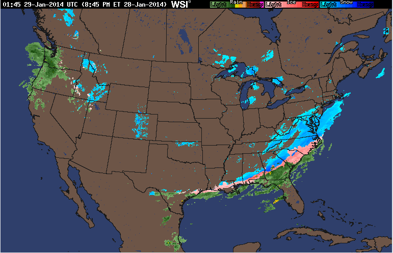
The national radar shows a large band of snow reaching from central Nebraska to western Pennsylvania.  Meanwhile Florida is still experiencing moderate rainfall, with Miami looking like it will receive a decent sized thunderstorm later on today.  On the western front, scattered snow storms and rain can be seen as well.
Current surface analysis shows a bevy of stationary fronts with several low pressure bands bringing snow/rain in the west and moving the large snowstorm over the midwest to the east.  There are two large high pressure systems in the northern midwest and over Georgia and Alabama.  
Wind chill forecasts for the next hour or so show warmer temperatures in the south that will melt any snow or ice left over from tuesday's unusual storm.  While the dark purple signifying dangerously cold temperatures reaches down from Canada into the northern Minnesota and Wisconsin making going outside dreadful once again.
Current Winds show relatively little action occurring across most of the U.S.  Parts of Arizona and New Mexico however, seem to be experiencing stronger winds due to a cold low pressure system moving through the area.

Thursday, January 30, 2014

Weather Forecast 1/30/14

Walking to class this morning I noticed small flakes falling gently and then disappearing.  After leaving that one class, there seemed to be 2-3 inches on the ground!  It seems at though the warmer temperatures (around 23 degrees) brought overcast skies and dumped several more inches today, snowing for about 5-6 full hours.
The current national radar shows the large storm that just passed through.  Also seasonal rains hit southern Florida and western Washington state.  Another snowy front travels over the mountain west.
Current surface analysis shows a large low pressure cold front moving across the mountain west, causing much of the western third of the nation to have overcast skies.
Wind chill temperatures around the country are pretty cool, keeping the ice/snow mixture that pelted Atlanta around for at least another day.  The low pressure system from the surface analysis map will most likely bring the purple cold air back down to the midwest for the weekend.
The jet stream today affects us directly from the west as opposed to yesterday's winds that were bringing down freezing air from Canada directly through Minnesota before stretching across the great lakes.

Wednesday, January 29, 2014

Weather Forecast 1/29/14

Walking to class this morning, i recorded temperatures in Eau Claire at a cool -5 with the wind chill causing it to feel approximately -10 to -15 degrees.  Today marks the third straight day where we have failed to see temperatures reach above zero degrees.  Other than the bitter cold, there only seems to be one or two clouds in my visible horizon.
Across the rest of the U.S. temperatures remain colder than normal with only California and Florida reaching temperatures in the mid 50's to low 60's.  
Current Surface analysis shows precipitation in the south once again today, with multiple news agencies reporting large amounts of car accidents and school postponements.  The northwest looks like it is experiencing mild to heavy rain and snowfall.  I predict that weather to reach the midwest by Thursday and the east coast just in time for Super Bowl Sunday.
The wind today across the U.S. is relatively mild with the midwest getting a break from the constant colder winds to receive some from the southwest.  
The jest stream however continues to deliver wind and cold air directly from the arctic into the upper midwest.  The jet stream will also keep the wintery weather mix from the northeast and push it out to the northern Atlantic instead.

Tuesday, January 28, 2014

Weather Forecast 1/28/14

Eau Claire was hit with bitter cold from up north again today.  Temperatures reached a high of around  -10 with the wind chill making it fell like 15 to 20 below.  After being pelted with 6 inches of snow over the weekend and having to deal with an even colder day on Monday, even with the sun out today's weather was more depressing than listening to Sarah Mclachlan sing about dying dogs on repeat for a week.
For some across the United States the weather was a little peculiar.  Snow and sleet hit the deep south for the first time this winter, which I'm sure sent the southerners scampering for shovels and ice picks.  
The surface analysis shows much of the U.S. enjoying the sunny skies of a high pressure system.  The low pressure system can be seen across the majority of the south shrouded in precipitation and cold temperatures.
the Windcast shows freezing air from Canada blasting through Minnesota on its way through the upper midwest.  While most of the U.S. had winds swirling from the south and west.  
Tomorrows Forecast shows a high pressure system moving out the storms the South saw today, melting the slight dusting they experience only once in a blue moon.  Wisconsin should be mostly clear with temperatures finally breaking 0 degrees.  A low pressure system seems to be moving eastward from Canada and will probably cause snow in the near future.

Friday, January 24, 2014

Weather Forecast 1/24/14

Walking to class this morning I noticed an overcast sky and recorded the temperature at 19 degrees.  At this current time, there is a steady snow falling with medium sized flakes.  Due to the colder weather, the snow seems light and fluffy and is not sticking too well.
  
The snow seems to have came from the northwesterly winds that are blowing in the region.  The east coast looks like it might warm up a little tomorrow due to the winds stemming from the south.  
Current temperature readings show the East coast getting the frigid weather we had yesterday, yet it will only last a day as temperatures will warm up tomorrow.
Surface analysis shows the warm band of air from the west moving eastward.  Also, the high pressure areas to the west will most likely move east to our direction and bring calmer weather with no snow.
Overall, the upper mid-west seems to be the only area with any notable weather occurring.  However, people living on the east coast should again prepare for more snow.