
I'm a little tired so lets get right to it. The current surface analysis shows almost what I predicted last night, which I pretty much guessed at but i'l take it. The high pressure system from new mexico pushed the low pressure band north, while also combining with the jet stream added warm temperatures which explains why the largest portion turned red, representing a warm front. Also, the trough currently in front of a cold low pressure system on the texan/new mexico border is sure to bring rough storms tomorrow in the tornado belt states. A better look at the approaching storms is below.

The radar show a large band of storms all the way through the heart of the U.S. I estimate the large high pressure areas will keep the storm fronts surrounded and inhibiting their movement to the east coast. It looks that at least a portion of California is getting precipitation, which is good cause we all know they desperately need it.

The jet stream shows the fastest winds along the storm front in the south. On top of that, it looks as if an inverted "omega" seems to be forming around the mountain west which would unfortunately lock us into turbulent weather for at least 3 days.
I was hoping to post about any current Tropical Storms or Cyclones, however, there are currently none on planet earth. So instead i scoured the internet to find cool weather images/gifs/clips (really just found them on reddit.com/r/weather)
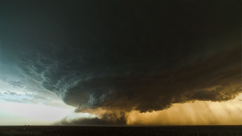
Here you can see an actual spinning supercell this was located in Booker, Texas (if you want to watch the whole video in HD, which I recommend, here you GO)

This one is pretty remarkable, especially with the context of those large grain drums in the foreground. If I ever have to choose between living in Kansas or Oklahoma remind me to look at this photo and then choose someplace as far and as safe away from either of those states where this cannot possibly happen.
No comments:
Post a Comment