Monday, February 24, 2014

Weather Update 2/24/24

With another 12+ inches of snow on the ground, this winter has officially entered into the Tyson Zone. (Scroll all the way down, its the second to the last email)  Anointing this winter into Tyson Zone lore is a quite a rare, but after having to walk through almost a month's total of days with negative weather to class, I feel I have the experience to do what I please.  I actually spent extra time looking up the statistics on that assumption.  Surprisingly, I was actually right, and real life statistics reveal our fair city of Eau Claire Wisconsin has for the past 5 weeks had an AVERAGE temperature of -4.2 degrees. (that's the average low temp but I walked to class before 9am) Also, you would probably find it interesting that before last weeks brief tease of warm weather (yay 30 degrees!!) the warmest average weekly temperature dating all the way back to January 19th was -7, our coldest from that span was a balmy -11 (Double Effin Digits!).  Walking to class almost felt like riding over the rockies on a moped. It was common practice to arrive at my early morning class, de-ice and remove my jacket before exclaiming, "WE'RE THERE" 

Thats all the complaining I have the energy to type, so now on to the actual weather update!
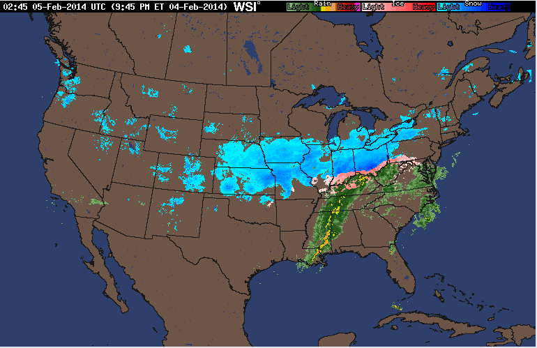
The current national radar shows the ever-present light blue blotches over the midwest, signifying snow if you haven't been paying attention to the past few maps.  The rainy season seems to be in full swing out on the northwest coast, with showers forming off the pacific and moving inland daily.  I believe this is the price they pay for winning the super bowl with the "best" fans and being obsessively annoying about it. SERIOUSLY SEATTLE IT"S F***KING ENOUGH ALREADY.  YOU DID NOT ACTUALLY HELP OUT ON THE FIELD. I totally lied about complaining, but moving on...
Current Surface analysis shows cloud cover forming along the stationary front moving above the Mountain West.  The high pressure system hovering over Montana looks to keep the clear skies we saw today a constant over the next 24 hours.  The absence of cloud cover tomorrow will keep temperatures low and the certainty that you will not be able to see for the first 5 minutes after entering a building.
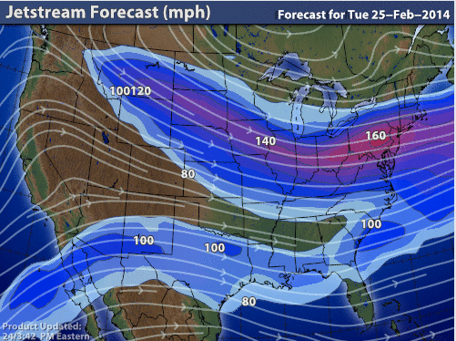
The jet stream forecast shows moderately high speeds over much of the midwest.  After last weeks dip into the warm southern winds, the jet stream returns to being fed from the frigid Canadian arctic north.  You would think we would at least catch a break from the Canadians after the recent ice hockey competitions in Sochi, but it seems our ability to catch a break is equal to THIS DOG'S ability of catching its toy.


Thursday, February 20, 2014

weather Update 2/20/14

The blog returns like this winter weather...in full apocalyptic force!  Today marks the second day this week that the combined states of Minnesota and Wisconsin are getting plastered by winter storms.  Here look at the current radar...
That massive storm hovering directly over Eau Claire arrived more than 4 hours ago.  Plus temperatures are in the mid to high twenties so the snow is very heavy, with several tweets from Eau Claire students saying their power lines are down.  Snow does seem better than the tornado warnings sent out to counties ranging from Mississippi all the way to Illinois and Indiana.  
Current analysis shows a large low pressure front moving the storms to the across the Nation.  The hard to identify Iso-bars show the "vortex" of the low pressure system right over Wisconsin.  This is causing swirling winds with gusts topping 25 MPH.  
Currently, my measurements have the snow at right about 6 inches of snow having fallen from this storm, with NO sign of letting up.  I'm hoping that classes are cancelled tomorrow, but I'm not overly optimistic.

In other weather related media I found two interesting Gifs of severe weather.  The first can be related to the weather we are currently experiencing here in Eau Claire, except instead of snow the Hong Kong airport was subjected to a torrential downpour in a matter of seconds.  The gif can be seen HERE.  The second gif is very cool in my opinion, as it hows the exact moment a tornado is formed.  It can be seen at this link HERE.  If you decided to actually click on the link, pay attention to the tree the newly formed tornado demolishes right off the road, boy that driver was lucky!

Check back tomorrow for updates on the final inch count on the snow storm pounding our fair state.

Friday, February 7, 2014

Weather Forecast 2/7/14

Today marked the 17!!!! day in a row where Eau Claire, WI encountered temperatures below ZERO degrees.  I know this sounds like whining but with the added wind chill and having to walk across that damn BRIDGE!  What makes it worse is when browsing the internet headlines from southern news outlets constantly play-up the school closures and poor driving of southern folk in snow.  And that's when it is 20 degrees ABOVE zero and there's only one to two inches of snow on the ground.  Now I will make an exception for Atlanta a couple weeks ago due to the fact that there was an inch of ice on the ground and not just snow.  Otherwise, I would compare the southern populations' fear of snow and cold weather to the people Tokyo's fear of large green monsters rising out of the pacific ocean.  In other non related news, here is a picture of the weather Dallas experienced yesterday afternoon...
...it doesn't seem like a lot of snow but I really don't think those cowboys could handle more than 2 inches.
Current surface analysis shows large high pressure systems across much of the midwest, eastern sea board, and behind several lower pressure systems in the west/northwest.
Current winds show mild speeds across the high pressure systems.  Out west, winds look to be exceeding speeds of 30mph, pushing storms further into the northern half of California.  
Current Wind chill temperatures shows us right around zero degrees which I fear I am getting as used to as Bane is to darkness. Sometimes I even catch myself day dreaming like Red Redding (Morgan Freeman) of Andy Dufresne in The Shawshank Redemption after he escaped to Mexico, except I dream of long johns, electric blankets and temperature gauges that read above the freezing point.

Tuesday, February 4, 2014

Weather Forecast 2/4/14

Walking to class this morning, I noticed temperatures right around zero degrees with the only visible clouds in the sky being airplane trails.
The current national radar shows a large storm system over much of the central U.S.  In the south over Mississippi and Alabama lies a large storm system which looks like it contains several large thunderstorms.  Where temperatures allow it, the large system turns into snow covering most of Ohio all the way through Kansas and Nebraska.
Current surface analysis shows the storms following a large low pressure system that is immediately chasing away higher pressurized areas away in the northeast.  Out west, another cold front seems to be passing through over the rockies.  
The wind chill across the U.S. shows bitter cold reaching down from Canada once again.  After a series of warmer winters, this one seems to have righted the ship, with temperatures reaching below zero becoming the norm for much of the northern states across the mid- and mountain west.
The jet stream shows more of the U.S. being affected by westerly winds compared to yesterday's that were dipping all the way down to Mexico before making a turn north.  The fastest winds seem to be at the forefront of the large storm system moving through the heart of the U.S.

Monday, February 3, 2014

Weather Forecast 2/3/14

Weekend Update:
Our weekend in Eau Claire unfortunately seemed to have been attacked by Mr.Freeze himself.  We were once again rocked by cold weather and winds keeping the wind chill below zero. 

Today, the weather stayed in the single digits with the wind chill dipping below zero.  The map below shows temperatures across the United States.
The image shows cold temperatures reaching below the canadian border all the way down to colorado.  Down south temperatures were crisp but mostly warm.

The jet stream radar shows the highest speeds across the low front on the eastern seaboard, with the precipitation arriving with the help of warmer winds brought up from the southwest.
Current surface analysis shows large low pressure systems moving across the south, with a major storm system over the eastern seaboard diminishing into the northern atlantic. Snow showers are scattered across much of the mountain west as well.