Thursday, May 8, 2014

Weather Update 5/8/17

Let's jump right in...Current surface analysis shows the large storm systems have slowly moved eastward today.  We experienced a fairly heavy storm today as did several other parts of the U.S.   The high pressure system that was over the Canadian Rockies moved southeast and as a consequence, is keeping that warm low pressure front over much of Minnesota and Wisconsin.  I expect further heavy storms tomorrow as the cold front moves through the state.  Out east, it looks as if the storms might get bottled up into Kentucky and through to Virginia.  If that doesn't occur than the high pressure system will move up the Eastern seaboard, and move the storms down to Georgia and Florida.  
The infrared satellite shows precipitation directly in front of the cold front seen in the surface analysis.  
The jet stream map shows the moisture laden southern winds helping the heavy rains in the U.S. heartland.  The westerlies that we are used to seem to inching closer to our state, hopefully bringing decent weather when they do.

In honor of the NFL draft finally arriving today i'd like to add a link to the Bears' first round selection and future all-pro (fingers crossed!) Kyle Fuller

Wednesday, May 7, 2014

Weather Update 5/7/14


I'm a little tired so lets get right to it.  The current surface analysis shows almost what I predicted last night, which I pretty much guessed at but i'l take it.  The high pressure system from new mexico pushed the low pressure band north, while also combining with the jet stream added warm temperatures which explains why the largest portion turned red, representing a warm front.  Also, the trough currently in front of a cold low pressure system on the texan/new mexico border is sure to bring rough storms tomorrow in the tornado belt states.  A better look at the approaching storms is below.
The radar show a large band of storms all the way through the heart of the U.S.  I estimate the large high pressure areas will keep the storm fronts surrounded and inhibiting their movement to the east coast.  It looks that at least a portion of California is getting precipitation, which is good cause we all know they desperately need it.  
The jet stream shows the fastest winds along the storm front in the south.  On top of that, it looks as if an inverted "omega" seems to be forming around the mountain west which would unfortunately lock us into turbulent weather for at least 3 days.

I was hoping to post about any current Tropical Storms or Cyclones, however, there are currently none on planet earth.  So instead i scoured the internet to find cool weather images/gifs/clips (really just found them on reddit.com/r/weather)
Here you can see an actual spinning supercell this was located in Booker, Texas (if you want to watch the whole video in HD, which I recommend, here you GO)
This one is pretty remarkable, especially with the context of those large grain drums in the foreground.  If I ever have to choose between living in Kansas or Oklahoma remind me to look at this photo and then choose someplace as far and as safe away from either of those states where this cannot possibly happen.


Tuesday, May 6, 2014

Weather Update 5/6/14

 Due to a certain Mexican-American holiday, I missed yesterdays weather update...
 No fear though, I bring extra internet weather finds before Today's update.
This is actually a long exposure picture but they are in fact La Palma Clouds.  I defer to wikipedia for an explanation, " La Palma receives almost all of its water supply due to the mar de nubes (sea of clouds), stratocumulus cloud at 1,200 m (3,937 ft)-1,600 m (5,249 ft) altitude, carried on the prevailing wind which blows from the north-east trade winds. The water condenses on the long needles of the trees and other vegetation, it then either drips onto the ground or runs down the trunk etc., into the ground. Eventually it collects inside the rock-strata, and is then drained via the galerias into aqueducts and pipes for distribution. The galerias have been cut into the rocks over centuries."
Here is a picture captioned, "Tornado formation in my backyard."  OP is from Kansas.


This Link is to an interesting GIF of a large thunderstorm that formed off the coast of Florida.


"Titan"-Nebraska

Now for the actual weather report, we begin as always, with the Current Surface analysis...
The sunshine we've enjoyed the past couple days has been wonderful, but it leaves us for the known future (at least until Friday).  As you can see above, there are several low pressure systems across the central band of states and another cluster above the canadian rockies.  The high pressure system currently residing in New Mexico is being straddled by troughs and will most likely push the band of L's north-east with likely large storms in the south arriving later this week. The Jet stream below will also help explain the rough weather approaching.

The jet stream shows high wind speeds in Baja Mexico and those same bands are currently traveling all the way up to the northern half of Minnesota.  This current pattern will bring us the warm temperatures that we haven't seen since early September. Of course the warm weather brings moisture to the air and when mixed with the cold low pressure system up in the rockies that's bound to travel east, storms will emerge.

We shall see tomorrow how the low pressure systems react to the current and expected conditions.

Thursday, May 1, 2014

Weather Report 5/1/14

The prodigal blog returns after...8 Weeks?!?! I just may have hit the snooze button one too many times.  But I return with the news that the weather is still as crappy as when I last reported so my fellow reader (s?) did not miss out on much; a snowstorm here, frigid temperatures there, all in all this semester's weather is worse than Rob Ford's judgement.   Even if I missed a decent sized portion of the blog time table, I vow to report on the weather everyday until the semester is over to hopefully win back some crucial points for my flailing grade.  So, without further ado I present the weather for May 1st 2014.
Current Surface analysis shows the end of another mid-latitude cyclone over much of the country, with the east coast still being threatened by copious amounts of rain.  Four High pressure areas are moving across the mountain west which will hopefully push the clouds enough for us in Eau Claire to finally see sunshine for the first time since the snow melted. The rain has stuck around due to an inverse "omega high" that has been stuck in between jet streams for the past week.
Here is the "precipicast" that shows a weeks worth of precipitation over the continental U.S.  Here we can see torrential rains pummeling the gulf coast with heavy flooding reported in the pan-handle of Florida.  The rest of the midwest and east coast saw similar precipitous amounts over the past week as well.  This is exactly the opposite after crossing the rockies, where drought has stricken the west and record high temperatures have been recorded along the coastline.  It has been so dry that forest fire warnings have already been announced.  
Current winds show the midwest finally receiving the normal WNW & NW winds we're accustomed to seeing, as opposed to the easterly ones that were spinning around the low pressure system that was in the area.  Winds out west are calm at the moment but are projected to speed up from now until the end of the weekend, which can be dangerous for the righteous dudes in SoCal. 

On a more solemn note, at least 40 have perished due to Tornados across Arkansas, Kentucky, North Carolina, and Alabama.  It is always sad to hear of these unfortunate souls and may they rest in peace.


Monday, February 24, 2014

Weather Update 2/24/24

With another 12+ inches of snow on the ground, this winter has officially entered into the Tyson Zone. (Scroll all the way down, its the second to the last email)  Anointing this winter into Tyson Zone lore is a quite a rare, but after having to walk through almost a month's total of days with negative weather to class, I feel I have the experience to do what I please.  I actually spent extra time looking up the statistics on that assumption.  Surprisingly, I was actually right, and real life statistics reveal our fair city of Eau Claire Wisconsin has for the past 5 weeks had an AVERAGE temperature of -4.2 degrees. (that's the average low temp but I walked to class before 9am) Also, you would probably find it interesting that before last weeks brief tease of warm weather (yay 30 degrees!!) the warmest average weekly temperature dating all the way back to January 19th was -7, our coldest from that span was a balmy -11 (Double Effin Digits!).  Walking to class almost felt like riding over the rockies on a moped. It was common practice to arrive at my early morning class, de-ice and remove my jacket before exclaiming, "WE'RE THERE" 

Thats all the complaining I have the energy to type, so now on to the actual weather update!
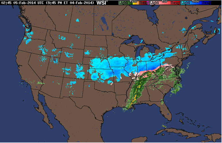
The current national radar shows the ever-present light blue blotches over the midwest, signifying snow if you haven't been paying attention to the past few maps.  The rainy season seems to be in full swing out on the northwest coast, with showers forming off the pacific and moving inland daily.  I believe this is the price they pay for winning the super bowl with the "best" fans and being obsessively annoying about it. SERIOUSLY SEATTLE IT"S F***KING ENOUGH ALREADY.  YOU DID NOT ACTUALLY HELP OUT ON THE FIELD. I totally lied about complaining, but moving on...
Current Surface analysis shows cloud cover forming along the stationary front moving above the Mountain West.  The high pressure system hovering over Montana looks to keep the clear skies we saw today a constant over the next 24 hours.  The absence of cloud cover tomorrow will keep temperatures low and the certainty that you will not be able to see for the first 5 minutes after entering a building.
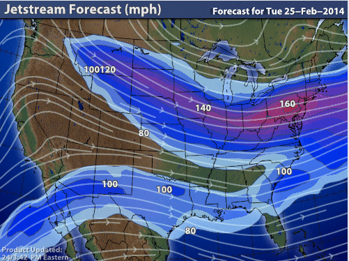
The jet stream forecast shows moderately high speeds over much of the midwest.  After last weeks dip into the warm southern winds, the jet stream returns to being fed from the frigid Canadian arctic north.  You would think we would at least catch a break from the Canadians after the recent ice hockey competitions in Sochi, but it seems our ability to catch a break is equal to THIS DOG'S ability of catching its toy.


Thursday, February 20, 2014

weather Update 2/20/14

The blog returns like this winter weather...in full apocalyptic force!  Today marks the second day this week that the combined states of Minnesota and Wisconsin are getting plastered by winter storms.  Here look at the current radar...
That massive storm hovering directly over Eau Claire arrived more than 4 hours ago.  Plus temperatures are in the mid to high twenties so the snow is very heavy, with several tweets from Eau Claire students saying their power lines are down.  Snow does seem better than the tornado warnings sent out to counties ranging from Mississippi all the way to Illinois and Indiana.  
Current analysis shows a large low pressure front moving the storms to the across the Nation.  The hard to identify Iso-bars show the "vortex" of the low pressure system right over Wisconsin.  This is causing swirling winds with gusts topping 25 MPH.  
Currently, my measurements have the snow at right about 6 inches of snow having fallen from this storm, with NO sign of letting up.  I'm hoping that classes are cancelled tomorrow, but I'm not overly optimistic.

In other weather related media I found two interesting Gifs of severe weather.  The first can be related to the weather we are currently experiencing here in Eau Claire, except instead of snow the Hong Kong airport was subjected to a torrential downpour in a matter of seconds.  The gif can be seen HERE.  The second gif is very cool in my opinion, as it hows the exact moment a tornado is formed.  It can be seen at this link HERE.  If you decided to actually click on the link, pay attention to the tree the newly formed tornado demolishes right off the road, boy that driver was lucky!

Check back tomorrow for updates on the final inch count on the snow storm pounding our fair state.

Friday, February 7, 2014

Weather Forecast 2/7/14

Today marked the 17!!!! day in a row where Eau Claire, WI encountered temperatures below ZERO degrees.  I know this sounds like whining but with the added wind chill and having to walk across that damn BRIDGE!  What makes it worse is when browsing the internet headlines from southern news outlets constantly play-up the school closures and poor driving of southern folk in snow.  And that's when it is 20 degrees ABOVE zero and there's only one to two inches of snow on the ground.  Now I will make an exception for Atlanta a couple weeks ago due to the fact that there was an inch of ice on the ground and not just snow.  Otherwise, I would compare the southern populations' fear of snow and cold weather to the people Tokyo's fear of large green monsters rising out of the pacific ocean.  In other non related news, here is a picture of the weather Dallas experienced yesterday afternoon...
...it doesn't seem like a lot of snow but I really don't think those cowboys could handle more than 2 inches.
Current surface analysis shows large high pressure systems across much of the midwest, eastern sea board, and behind several lower pressure systems in the west/northwest.
Current winds show mild speeds across the high pressure systems.  Out west, winds look to be exceeding speeds of 30mph, pushing storms further into the northern half of California.  
Current Wind chill temperatures shows us right around zero degrees which I fear I am getting as used to as Bane is to darkness. Sometimes I even catch myself day dreaming like Red Redding (Morgan Freeman) of Andy Dufresne in The Shawshank Redemption after he escaped to Mexico, except I dream of long johns, electric blankets and temperature gauges that read above the freezing point.

Tuesday, February 4, 2014

Weather Forecast 2/4/14

Walking to class this morning, I noticed temperatures right around zero degrees with the only visible clouds in the sky being airplane trails.
The current national radar shows a large storm system over much of the central U.S.  In the south over Mississippi and Alabama lies a large storm system which looks like it contains several large thunderstorms.  Where temperatures allow it, the large system turns into snow covering most of Ohio all the way through Kansas and Nebraska.
Current surface analysis shows the storms following a large low pressure system that is immediately chasing away higher pressurized areas away in the northeast.  Out west, another cold front seems to be passing through over the rockies.  
The wind chill across the U.S. shows bitter cold reaching down from Canada once again.  After a series of warmer winters, this one seems to have righted the ship, with temperatures reaching below zero becoming the norm for much of the northern states across the mid- and mountain west.
The jet stream shows more of the U.S. being affected by westerly winds compared to yesterday's that were dipping all the way down to Mexico before making a turn north.  The fastest winds seem to be at the forefront of the large storm system moving through the heart of the U.S.

Monday, February 3, 2014

Weather Forecast 2/3/14

Weekend Update:
Our weekend in Eau Claire unfortunately seemed to have been attacked by Mr.Freeze himself.  We were once again rocked by cold weather and winds keeping the wind chill below zero. 

Today, the weather stayed in the single digits with the wind chill dipping below zero.  The map below shows temperatures across the United States.
The image shows cold temperatures reaching below the canadian border all the way down to colorado.  Down south temperatures were crisp but mostly warm.

The jet stream radar shows the highest speeds across the low front on the eastern seaboard, with the precipitation arriving with the help of warmer winds brought up from the southwest.
Current surface analysis shows large low pressure systems moving across the south, with a major storm system over the eastern seaboard diminishing into the northern atlantic. Snow showers are scattered across much of the mountain west as well.


Friday, January 31, 2014

Weather Forecast 1/31/14

During today's walk to class I recorded temperatures back in the negatives at -6 degrees with the wind chill making it feel like -14.  The walk was especially arduous today due to the 4-5 inches we received yesterday.  It wasn't until the bridge that I noticed the wind blowing at about 5 MPH from the WSW.  Skies were clear with few clouds high above in the atmosphere.
The national radar shows a large band of snow reaching from central Nebraska to western Pennsylvania.  Meanwhile Florida is still experiencing moderate rainfall, with Miami looking like it will receive a decent sized thunderstorm later on today.  On the western front, scattered snow storms and rain can be seen as well.
Current surface analysis shows a bevy of stationary fronts with several low pressure bands bringing snow/rain in the west and moving the large snowstorm over the midwest to the east.  There are two large high pressure systems in the northern midwest and over Georgia and Alabama.  
Wind chill forecasts for the next hour or so show warmer temperatures in the south that will melt any snow or ice left over from tuesday's unusual storm.  While the dark purple signifying dangerously cold temperatures reaches down from Canada into the northern Minnesota and Wisconsin making going outside dreadful once again.
Current Winds show relatively little action occurring across most of the U.S.  Parts of Arizona and New Mexico however, seem to be experiencing stronger winds due to a cold low pressure system moving through the area.

Thursday, January 30, 2014

Weather Forecast 1/30/14

Walking to class this morning I noticed small flakes falling gently and then disappearing.  After leaving that one class, there seemed to be 2-3 inches on the ground!  It seems at though the warmer temperatures (around 23 degrees) brought overcast skies and dumped several more inches today, snowing for about 5-6 full hours.
The current national radar shows the large storm that just passed through.  Also seasonal rains hit southern Florida and western Washington state.  Another snowy front travels over the mountain west.
Current surface analysis shows a large low pressure cold front moving across the mountain west, causing much of the western third of the nation to have overcast skies.
Wind chill temperatures around the country are pretty cool, keeping the ice/snow mixture that pelted Atlanta around for at least another day.  The low pressure system from the surface analysis map will most likely bring the purple cold air back down to the midwest for the weekend.
The jet stream today affects us directly from the west as opposed to yesterday's winds that were bringing down freezing air from Canada directly through Minnesota before stretching across the great lakes.

Wednesday, January 29, 2014

Weather Forecast 1/29/14

Walking to class this morning, i recorded temperatures in Eau Claire at a cool -5 with the wind chill causing it to feel approximately -10 to -15 degrees.  Today marks the third straight day where we have failed to see temperatures reach above zero degrees.  Other than the bitter cold, there only seems to be one or two clouds in my visible horizon.
Across the rest of the U.S. temperatures remain colder than normal with only California and Florida reaching temperatures in the mid 50's to low 60's.  
Current Surface analysis shows precipitation in the south once again today, with multiple news agencies reporting large amounts of car accidents and school postponements.  The northwest looks like it is experiencing mild to heavy rain and snowfall.  I predict that weather to reach the midwest by Thursday and the east coast just in time for Super Bowl Sunday.
The wind today across the U.S. is relatively mild with the midwest getting a break from the constant colder winds to receive some from the southwest.  
The jest stream however continues to deliver wind and cold air directly from the arctic into the upper midwest.  The jet stream will also keep the wintery weather mix from the northeast and push it out to the northern Atlantic instead.

Tuesday, January 28, 2014

Weather Forecast 1/28/14

Eau Claire was hit with bitter cold from up north again today.  Temperatures reached a high of around  -10 with the wind chill making it fell like 15 to 20 below.  After being pelted with 6 inches of snow over the weekend and having to deal with an even colder day on Monday, even with the sun out today's weather was more depressing than listening to Sarah Mclachlan sing about dying dogs on repeat for a week.
For some across the United States the weather was a little peculiar.  Snow and sleet hit the deep south for the first time this winter, which I'm sure sent the southerners scampering for shovels and ice picks.  
The surface analysis shows much of the U.S. enjoying the sunny skies of a high pressure system.  The low pressure system can be seen across the majority of the south shrouded in precipitation and cold temperatures.
the Windcast shows freezing air from Canada blasting through Minnesota on its way through the upper midwest.  While most of the U.S. had winds swirling from the south and west.  
Tomorrows Forecast shows a high pressure system moving out the storms the South saw today, melting the slight dusting they experience only once in a blue moon.  Wisconsin should be mostly clear with temperatures finally breaking 0 degrees.  A low pressure system seems to be moving eastward from Canada and will probably cause snow in the near future.

Friday, January 24, 2014

Weather Forecast 1/24/14

Walking to class this morning I noticed an overcast sky and recorded the temperature at 19 degrees.  At this current time, there is a steady snow falling with medium sized flakes.  Due to the colder weather, the snow seems light and fluffy and is not sticking too well.
  
The snow seems to have came from the northwesterly winds that are blowing in the region.  The east coast looks like it might warm up a little tomorrow due to the winds stemming from the south.  
Current temperature readings show the East coast getting the frigid weather we had yesterday, yet it will only last a day as temperatures will warm up tomorrow.
Surface analysis shows the warm band of air from the west moving eastward.  Also, the high pressure areas to the west will most likely move east to our direction and bring calmer weather with no snow.
Overall, the upper mid-west seems to be the only area with any notable weather occurring.  However, people living on the east coast should again prepare for more snow.